 |
| Robert making gassing up look easy in KC. |
Distance today: 459.6 miles
Total to date: 667.47 miles
Today Robert & I left his home & headed off due north from KS to NE. Left around 08 something & finished our day about 1700ish. Headed out of the KC area without any probs or morning rush hour traffic. I decided to cover my bag & wear my rain jacket in preparation for the forecasted rain, which was a good decision.
We passed by St. Joseph, MO, home of the Pony Express.
 |
| Stained Glass at Trail's End Restaurant |
During its 19 months of operation, it reduced the time for messages to travel between the Atlantic and Pacific coasts to about 10 days. From April 3, 1860, to October 1861, it became the West's most direct means of east–west communication before the telegraph was established and was vital for tying the new state of California with the rest of the United States.
I find this history fascinating & the idea of travelling over the same country on a steel horse somehow ironic. Can you imagine travelling by horseback as quickly as possible over completely remote country?!
 |
| Robert at the rest stop in his "haz mat" suit |
Although we initially headed out with no rain, we quickly ran into some & man, did it pour! I had on my rain jacket & jeans. Made the conscious decision to NOT put on any rain pants for knew we would pass out of the rain eventually & be dry by day's end. (And this did work out for me!) Robert put on his rain gear under a viaduct where a group of about 5 motorcyclists had also gathered along the highway to wait out of the rain. These guys were from NV & TX & were on their own road trip. After about an hour of really hard rain, we stopped at a roadside rest stop to just let some of the rain pass. Eventually we just went for it & managed to drive out of the rain.
 |
| We're soaked but still smilin in this selfie! |
After our morning & early afternoon of rain, the sun came out & the scenery was beautiful. I don't know why I thought NE would be mostly agricultural fields with little to no trees.
I-80 follows the Platte River which, like every other waterway we passed, was flooded. Being the River Rat that I am I started thinking about this river. From researching the river's specifics, I learned that this river is about 310 miles long but measured from its farthest source via its tributary, the North Platte River, it flows for over 1,050 miles.
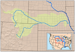 |
| Platte watershed map |
The Platte over most of its length is a muddy, broad, shallow, meandering stream with a swampy bottom and many islands—a braided stream. These characteristics made it too difficult for canoe travel, and it was never used as a major navigation route by European-American trappers or explorers.
We decided to stop at North Platte, NE for the night at a Motel 6. Ironically this motel was right alongside the river.
 |
| Motel 6 along flooded Platte River |
 |
| Platte River |
Never thought N. Platte would be a destination location but there was alot of activity in this town. Buffalo Bill Cody's Farm is 5 miles away.

 Needless to say, there is alot of Buffalo Bill tourist traps here too!
After dinner at a place that was like a Mexican Subway, we returned to the hotel & after a nightcap, I crashed, grateful for another safe & fun day of travel. Tomorrow Wyoming!!!!
No comments:
Post a Comment